The Salanie Gold Project in Gabon is located 16km from the major town of Lambarene, and less than 2km from the sealed N1 highway and lies within the Company’s 100% owned Keri Permit (G4-456).
Historical mining at Salanie in the mid-1950’s produced over 20,000 ounces of gold at 12g/t Au from quartz veins and alluvial workings. Reports indicate that 10g/t Au was sent to tailings during this period. The area has been untested by modern exploration for over 70 years.
Highlights:
12km trend of Archaean greenstone with gold occurrences (alluvial and hard rock) noted along the trend
Two mineralised areas confirmed (Salanie Fault and P6 Prospect) containing high-grade gold samples within an open 12km gold trend.
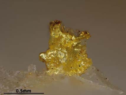
Multiple occurrences of visible gold in quartz veining – assaying up to 429g/t Au and 53g/t Au over +2.5km wide in veining
Figure 1: Salanie interpretated geology with gold prospects and peak sampling results.
Visible gold at the A1 Prospect – 429g/t Au (Refer Table 1).
A1 is a key defined prospect:
The A1 Prospect is part of the 1.5km long ‘Salanie Fault’ vein system identified in historical mapping from mid-1950’s with numerous gold occurrences noted along the trend;
Field work has confirmed a strong broad structure at A1, with trench results of 2m @ 17g/t Au within 10.3m @ 3.4g/t Au; and separately 1.4m @ 15.7g/t Au
Mapping indicates a 20m+ wide zone that extends for over 250m
Soil geochemistry displays an open 1.3km gold and multi-element anomaly to the south of the Salanie Fault.
A 1.5km controlling structure from A1 to A5 has been identified through noted visible gold and numerous rock chips along trend returning >10g/t Au
Figure 2 : Historical Mining Operations in the A3 Vein Area at Salane (c.1950)